Category / Map design

    Loading posts...
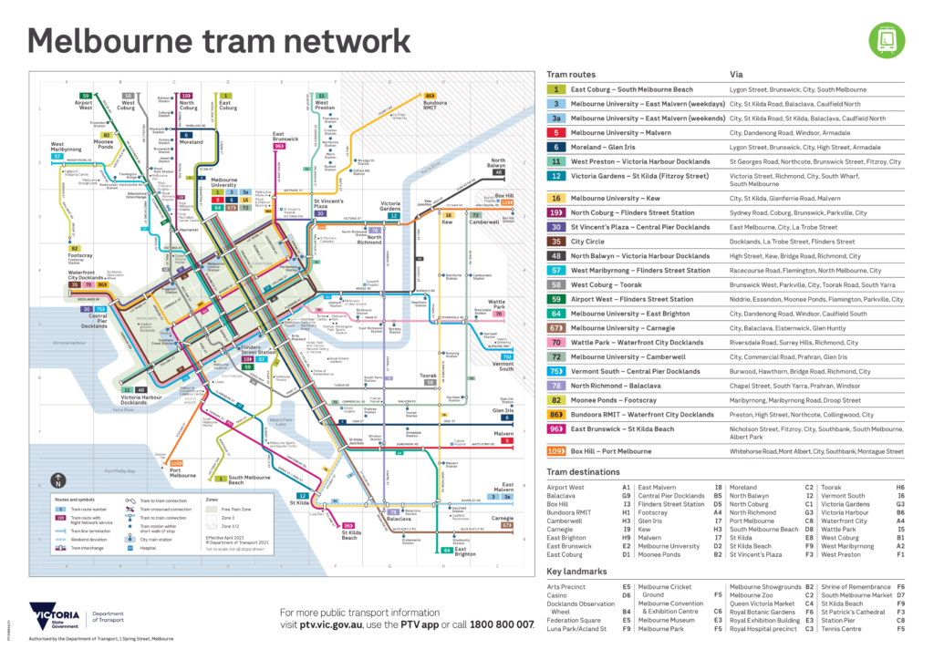
  • The new Melbourne tram map for 2021

    Earlier in May, the Department of Transport released the first major update in four years to Melbourne’s tram network map. We don’t get very many official public transport map updates in Victoria, so when they do happen they are extra exciting! You can see a video version of this post using the link below: I’m…

  • Why Skybus should not be on a rail map

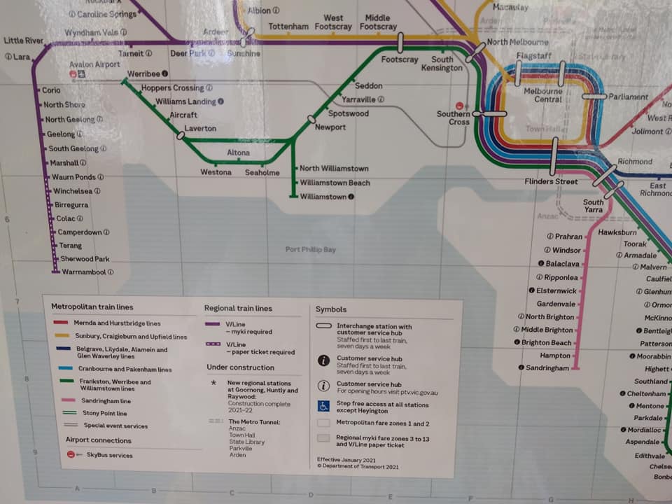
    This is my second post about the new version of the Victorian Rail Network Map that PTV have started distributing in trains – as shown in my previous post (thanks again to Mark Williams for the photos). I’ve already talked about my gripe with including things under construction on an operational map. My other main…

  • Why showing things under construction on a transport map is a bad idea

    I’d been considering writing a post on this topic for a while, inspired by the ongoing tradition of Sydney including things that don’t currently exist on their operational network maps.     But now it seems that PTV in Victoria have been inspired by our northern neighbours and applied this thinking to our own rail…

  • Where to find bicycle maps for Melbourne

    I have posted before about journey planning for bikes over on my main blog. But what about maps showing bike routes and information in general? There are several great resources out there to help, most of them community-made. If you have to pick one, I think that the best overall is OpenCycleMap and its associated…

  • Mapping local words in Melbourne

    For my next project, I will be making a couple of maps to show vocabulary used to describe places or things that are specific to a particular location in Melbourne. There is existing ongoing research called the Linguistics Roadshow which already maps some of the few regionalisms that exist in Australia for things like potato…

  • Survey clipboard with a blue pen against a green background with three options from top to bottom - neutral face, smiley face and sad face

    Cartography based on community feedback

    Those who follow me on Twitter or Facebook may have already seen the announcement of my latest and largest mapping project – the Melbourne Transport Map. This will be a map displaying all public transport options within Greater Melbourne. Community input As this is such a large undertaking, I have decided to take a different…

  • How the Suburban Rail Loop will transform Melbourne’s transport maps

    See the full project description and download link here. It is difficult to overstate how transformative the recently-announced Suburban Rail Loop will be for Melbourne’s transport network. Without getting into the technical transport details, it will make intra-suburban and cross-city travel much easier than it is today. One of the most significant aspects of the…

  • What are schematic maps?

    After the publication of my schematic public transport map of Chernarus, there was some confusion about its design and purpose. Hopefully this post will clear things up!   What is a schematic map? Put simply, a schematic map does not necessarily represent geography. Instead, it is designed to show nodes and the connections between them.…