

In the midst of this pandemic, there is not much current data available to know the exact impacts on our communities.
As a result, I am turning to the slightly older but incredibly comprehensive ABS Census to understand how COVID-19 (coronavirus) might impact people and communities.
In summary, I have extracted a selection of what I think are the most relevant datasets that would have an impact on how different areas experience the COVID-19 crisis. These are:
- Internet access at home
- People living alone
- Where health/social assistance, logistics and retail workers live
- People working from home (pre-pandemic)
There are many observations to make from the data. I hope to do some followup posts and maps going into more detail on some of these topics over the next few weeks.
You can see full-screen versions of the two dashboards above here and here. There are links to the graphs at the end of this post.
The main points that I think are worth highlighting from this overview are:
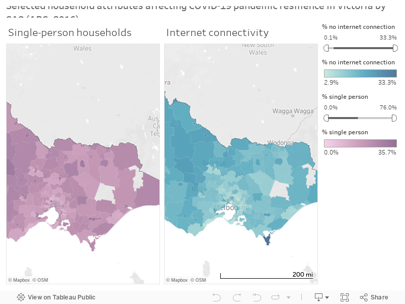
- There are several large areas of Melbourne where more than 1 in 5 households do not have internet access. This is mainly in the northern and north-western suburbs of Lalor, Thomastown, Fawkner and St Albans. A large area to the north of Geelong around Corio also falls into this category, as well as regional and country areas (e.g. Maryborough, Kerang and Morwell). These are largely, though not entirely, correlated with SEIFA. Access to the internet is obviously increasingly important during this pandemic as more and more key services move online. Those without access may find themselves at a significant disadvantage, particularly with public internet access points now being closed (e.g. public libraries).
- Areas with a large proportion of single-person households are mostly concentrated around Melbourne’s CBD. This is probably due to the large student populations. However, there are other clusters around Melbourne and Victoria, such as Mentone/Mordialloc, Croydon and Benalla. Under lockdown, people living alone are more prone to suffer feelings of loneliness and social disconnection, potentially affecting their mental health.
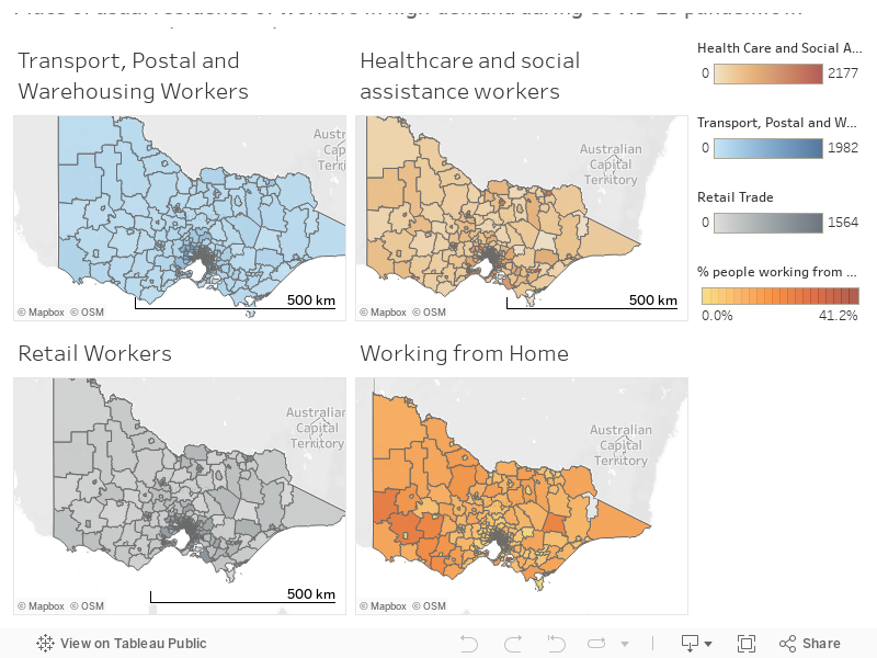
- Healthcare and social assistance workers do not necessarily live near hospitals. I must admit that this one caught me by surprise. The top three areas for workers in healthcare and social assistance are Richmond, Tarneit and Kew in that order. The usual place of residence for workers in this category would be affected by a range of complex factors, such as ageing populations, proportion of people with a disability and housing prices. I think that this question deserves a lot more analysis in a separate post as there is a lot to discuss.
- Logistics workers tend to live in the outer suburbs of Melbourne. Places like Tarneit, Sunbury and Wallan have high numbers of workers in this category. All three feature large industrial areas so this probably comes as no surprise. However, all three also suffer high rates of forced car ownership and transport disadvantage. Getting to and from work safely during a pandemic would be of particular importance for workers in these areas to keep goods moving through the supply chain.
- Retail workers seem to be scattered across all populated areas fairly evenly. I can’t make out any obvious patterns for where retail workers usually reside. The main point to make here is similar to that of logistics workers. To keep our shops open and servicing the public, it’s vital to ensure that workers can get to and from their employment safely. Doing so in some outer suburbs is difficult or impossible without a car, which is expensive to use and run (hence relatively low rates of car ownership in many of these areas for households with lower incomes).
- The most common places for people to already have been working from home are in rural areas of western and eastern Victoria. This was another one that surprised me, but makes sense when you look at which places these are. French Island comes out far on top with over 41% of residents there reporting that they worked from home. As with French Island, other areas with high rates of working from home have high levels of agricultural activity, suggesting that these are mainly farmers working on their own properties. Within Melbourne’s built-up areas, working from home is generally correlated with a high-SEIFA score, concentrated in the inner/middle east and south-eastern suburbs.
I hope to dive a bit deeper into some of this data over the coming weeks.
If you have any suggestions or thoughts, please let me know!