Distances between Melbourne railway stations – a quick map
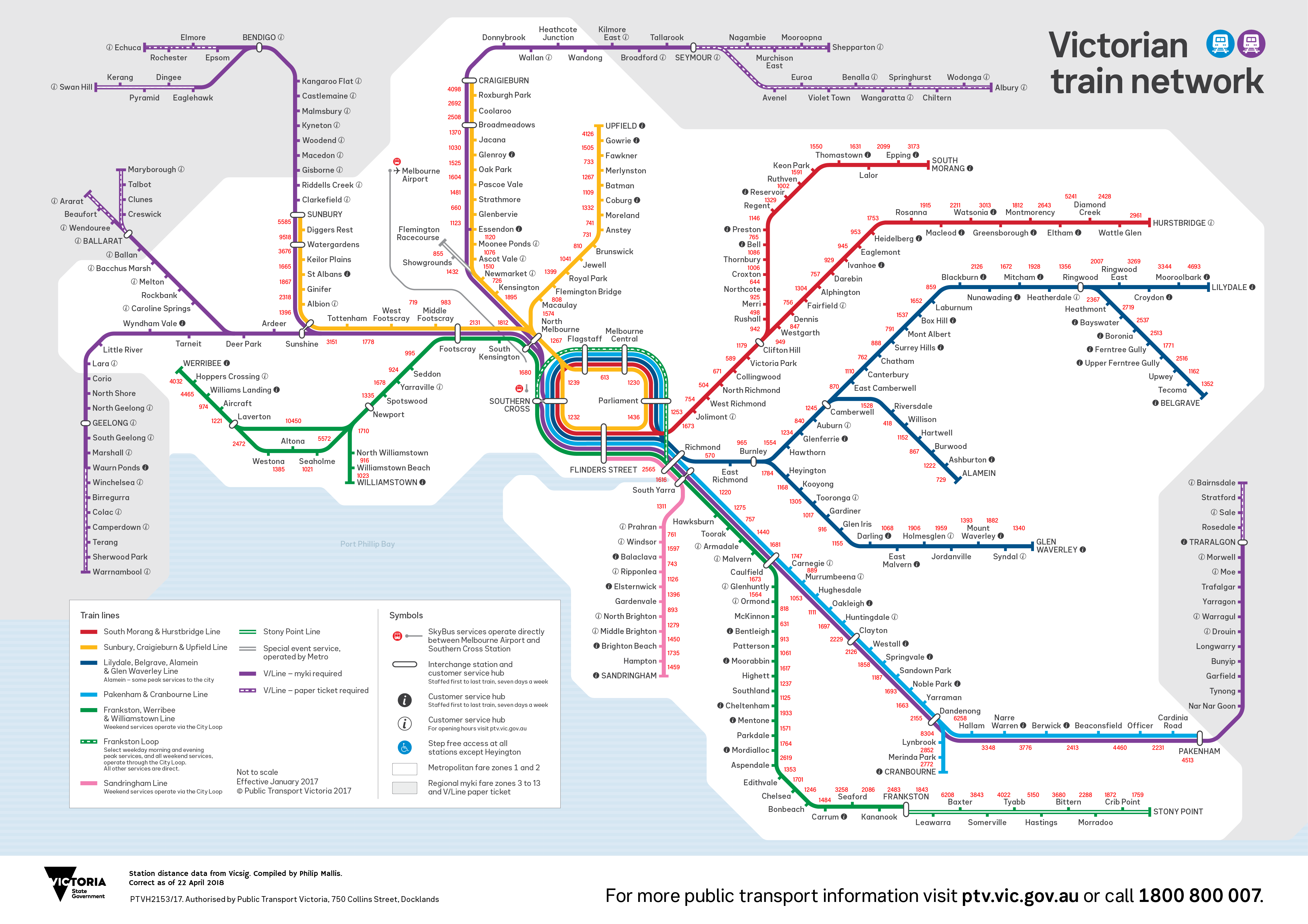
I spent a few days putting together a map that shows the distances between railway stations on Melbourne’s metropolitan rail network. The spacing has been calculated and placed onto the current official PTV Victorian rail network map.
The distance data is taken from the Vicsig website’s line guides (which also has a lot of other interesting stuff on railways). I simply subtracted the distance recorded for each station from the next one along the line as the information is displayed as distances from Spencer Street/Southern Cross Station.
Distances shown are not ‘as the crow flies’ but following the route of the tracks. All figures are in metres.
Summary of key points
- The furthest distance between stations on the metropolitan network is between Newport and Laverton (10,450 metres)
- The shortest distance between stations on the metropolitan network is between Riversdale and Willison (418 metres)
- The line with the longest mean distance between stations is the Stony Point Line (mean distance of 3,407 metres between stations)
- The line with the shortest mean distance between stations is the Alamein line (mean distance of 1,145 metres between stations)
Some more detailed information
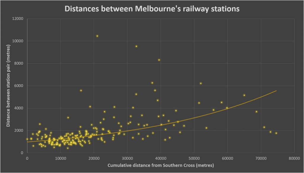
The graph below shows the relationship between cumulative distance from Southern Cross/Spencer Street Station and station spacing.
You can see how spacing increases the further away that the stations are located from the CBD.
The 10 furthest and smallest distances between station pairs are shown in the table below.
10 furthest station distances on Melbourne metropolitan rail network
| Station pair | Distance between stations (metres) | |
|---|---|---|
| 1 | Newport - Laverton | 10450 |
| 2 | Watergardens - Diggers Rest | 9518 |
| 3 | Dandenong - Lynbrook | 8304 |
| 4 | Dandenong - Hallam | 6258 |
| 5 | Leawarra - Baxter | 6208 |
| 6 | Diggers Rest - Sunbury | 5585 |
| 7 | Newport - Seaholme | 5572 |
| 8 | Eltham - Diamond Creek | 5241 |
| 9 | Tyabb - Hastings | 5150 |
| 10 | Moroolbark - Lilydale | 4693 |
10 shortest station distances on Melbourne metropolitan rail network
| Station pair | Distance between stations (metres) | |
|---|---|---|
| 1 | Riversdale - Willison | 418 |
| 2 | Rushall - Merri | 498 |
| 3 | West Richmond - North Richmond | 504 |
| 4 | Richmond - East Richmond | 570 |
| 5 | Collingwood - Victoria Park | 589 |
| 6 | Flagstaff - Melbourne Central | 613 |
| 7 | McKinnon - Bentleigh | 631 |
| 8 | Northcote - Croxton | 644 |
| 9 | Glenbervie - Strathmore | 660 |
| 10 | North Richmond - Collingwood | 671 |
Get the data
You can download the raw data (.xlsx spreadsheet) here: https://maps.philipmallis.com/wp-content/uploads/2018/04/Distance-between-Melbourne-railway-stations.xlsx


13 Comments
Join the discussion and tell us your opinion.
The link to the full size map isn’t working
Apologies for that, thanks for pointing it out. Should be fixed now 🙂
Given that the Flemington/Showgrounds line does not stop at Newmarket or Kensington, which are stations included on the Craigieburn line, might it be appropriate to include a North Melbourne – Showgrounds station pair for the Flemington line?
Hi Kevin, thanks for your comment! I did consider including station pairings like that in similar situations as well (e.g. the MATH stations where Pakenham/Cranbourne Line trains don’t usually stop) but decided that it wasn’t the object of doing this map. Rather, this is designed to show gaps between actual station locations rather than operationally. It would be another interesting exercise though – there would be a few sections in similar situations.
What is the longest distance between stations when you consider express trains? The one I am thinking is Box Hill – Richmond.
Good question! It’s hard to answer because there are some rare express trains that run for very long distances to stable at the end of the day, eg Southern Cross to Frankston . You would need some strict parameters to work out an ams
Good stuff mate, fantastic information!
Thank you! Glad you found it interesting 🙂
Found this really interesting. Great work, what technology did you use to work it out?
Thanks! I went through VicSig’s line diagrams and added them into the map: https://vicsig.net/index.php?page=infrastructure§ion=lineguide. I edited the map in Adobe Illustrator.
Bell and Preston are 600 metres apart Newport and Laverton have 3 stations between Seaholme Altona and Westona
West Footscray to Middle Footscray is a stones throw. Surely that’s in the top 10 shortest.
The growth along the Werribee line justifies a station or three to be built along the line between Newport and Laverton. Back in 1985, the station called Mobiltown closed. The area’s population has increased, and a shopping district called Millers Junction has opened across the road from Mobiltown.