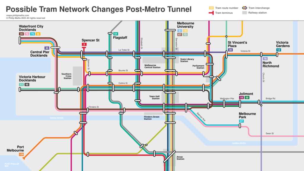
Possible post-Metro Tunnel Melbourne tram network
This is a quick map I have made to show what I think will happen to Melbourne’s tram network after the Metro Tunnel opens in 2024.

If you’re interested in learning more about this, please see my video on this topic over on my YouTube channel below.
7 Comments
Join the discussion and tell us your opinion.
They could merge routes 30 & 78 and renumber it as route 38. It would provide direct tram access to the Chapel Street precinct from the city, as well as accessible trams for the Church-Chapel Street corridor.
This would be fab for easier access to Chapel St from the inner north (where it’s currently a 3 tram hop from Brunswick). From memory there’s no existing left-hand turn from Church onto Victoria St
You are correct, only right turn in order to access Kew Depot. Wouldn’t take much to duplicate the terminal and install a left turn track, like they did for route 48 so it could run along Collins Street.
Re: Claws Route 38 idea, I’d actually advocate merging the Routes 12 and 78.
Reconfiguring the turning points at Victoria Street and Church, as well as Park Street and Fitzroy Street, you could actually create an Inner Suburban circle service.
St.Kilda Beach – St Kilda West – South Melbourne – City (Collins or La Trobe Street) – North Richmond – Richmond – Prahran – Windsor – Balaclava – St Kilda Beach
That could work.
This is really helpful, Philip! Based on reasonable assumptions too. I’m really curious about how the plans for Fishermans Bend will affect this.
Well under the Napthine government, tram routes from Elizabeth Street would have been sent west to serve Fisherman’s Bend, to compensate for scrapping the metro tunnel, which was the worst decision he ever made. Glad it was reversed.