Melbourne train map with Suburban Rail Loop

A different way of looking at the network

The announcement of the Suburban Rail Loop this week has had a huge impact on discussions about Melbourne’s public transport network.

As outlined in this partner post, it can also have significant implications for cartography and how we conceptualise our rail network. This map is one of many exciting possibilities and I hope to explore more of these in the near future.
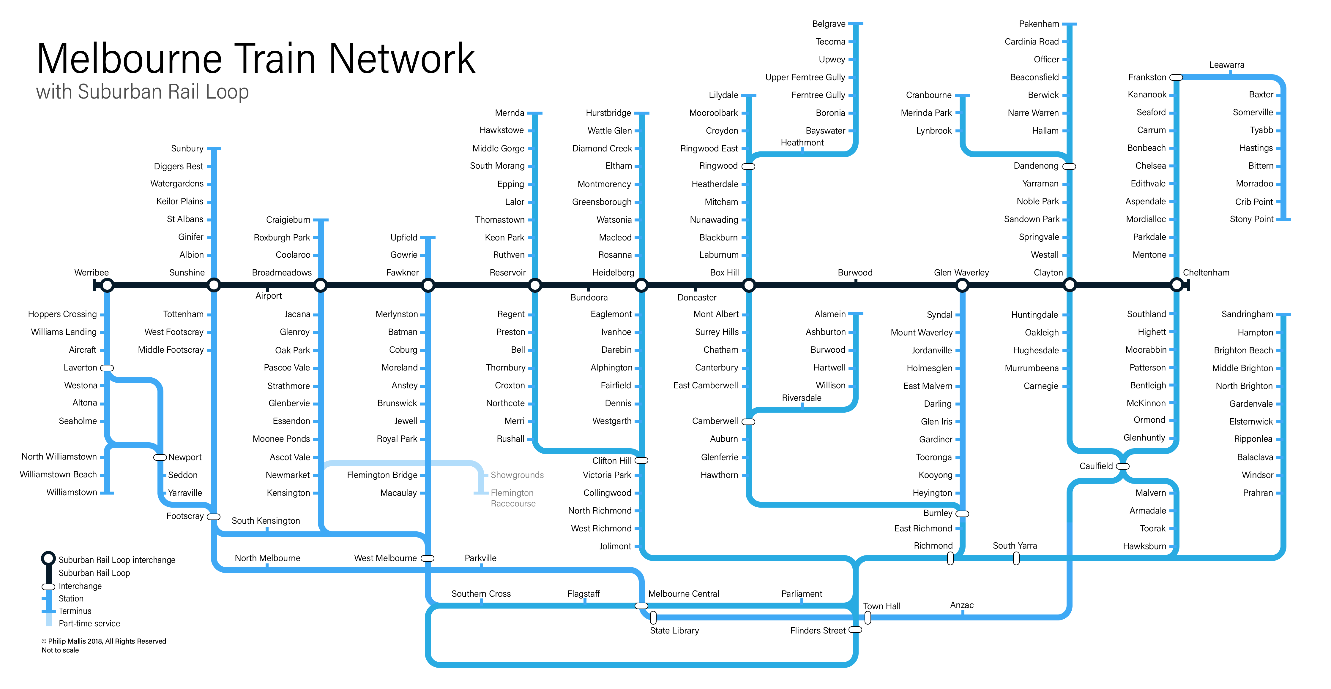
The Suburban Rail Loop

At present, Melbourne’s transport lines are largely radial. That is, they spread outwards like a spider’s web from the city centre. The heavy rail network is no exception.

On Wednesday last week, the Victorian Government surprised pretty much everyone by announcing a 90 kilometre circular route around Melbourne’s middle and outer suburbs. The proposal connects every pretty much rail line together and opens up significantly improved opportunities for intra-suburban and cross-city travel.

While the plans are still in the concept stage, it promises up to 12 potential stations along its length:

  • Werribee
  • Sunshine
  • Melbourne Airport
  • Broadmeadows
  • Fawkner
  • Reservoir
  • Bundoora (new)
  • Heidelberg
  • Doncaster (new)
  • Box Hill
  • Burwood (new)
  • Glen Waverley
  • Monash (new)
  • Clayton
  • Cheltenham

The Map

The project finally allows us to truly break free from the traditional ‘hub and spoke’-style maps of our existing radial system that have been the staple of transport maps in Victoria for decades.

This map uses the Suburban Rail Loop (SRL) as the focus of the network, rather than the traditional City Loop and CBD track.

I should also note that this map includes Melbourne Metro 1, as this project is currently under construction. Other proposed rail projects are omitted as they are not currently being built. This is a purely subjective judgement call on my part for the purposes of this map only.

Projecting the rail lines along these axes gives us a different view of the network. The new connectivity offered by the SRL is immediately obvious in this design and shows how the opportunities could work.

Of course, the view of the existing network is changed as well. While there have been some great attempts in the past to adopt a different approach to the radial network maps, this has been very difficult without a different logical focus from the City Loop. The SRL provides that new focal point and allows for this kind of a map to work.

Future Development

This is a fairly quick and dirty map showing one of the many possibilities afforded by the Suburban Rail Loop. I would highly encourage anyone else who is interested to use this opportunity to truly think differently about how our transport system could be cartographically reconceptualised and make your own maps in this vein.

If you have any feedback or suggestions for improvement, please let me know.