Like many other regional cities in Victoria, Geelong used to have its own tram network.
It was the first in the state to face the axe during the post-war removal of tram systems across Australia and the world. It was formally closed in 1956, having operated along more or less the same tracks since 1912.
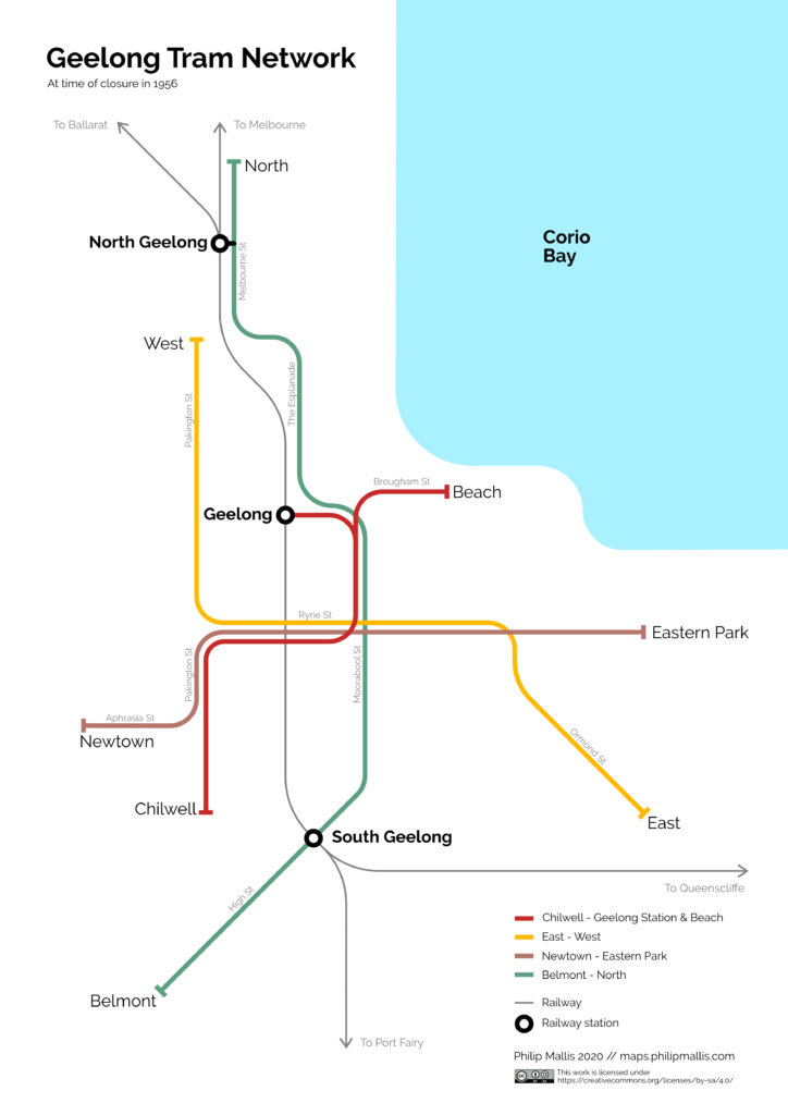
This is a quick map showing a schematised version of the network at its closure.
The Network
Despite being Victoria’s second-largest city, there is surprisingly little available documentation on Geelong’s trams – especially maps. This may be because almost all traces of the network have been erased from the city’s streets. This compares to Ballarat and Bendigo which both continue to operate heritage trams and museums. In fact, this is where some of the surviving trams of Geelong now live.
This map by Ken McCarthy in the February 1999 edition of the Trolleywire newsletter was the only official map that I could find. As a result, this is the main one that I have used to understand the network.
Someone has also put together this Google Map showing all the locations of tracks in its history (including those leading to Cunningham Pier that were closed in 1938). Julian Calaby also very kindly provided me with some maps from the book Last Tram at 11 by William F Scott which includes a section on the history of Geelong’s trams.
The other main resources that I have used is this ‘Mac’s Key to Geelong’ street directory from 1938, which is fascinating read in its own right. This aerial photograph of central Geelong from the 1960s also shows the tram tracks in this area quite clearly.
The Map
The map has a fairly simple and clean design with major street names for wayfinding and orientation. Passenger railways in operation at the time are also shown on the map (note that the present-day line to Warrnambool used to operate through to Port Fairy). There is a small legend in the bottom right hand corner.
It shows the four through lines operating on the network in 1956. They had changed a couple of times over the previous few decades as small extensions and modifications were made to tracks.
Tram stops
I was planning to add tram stops to this map but I could not find any reliable source to show where they were. I tried looking through aerial images, street-level photographs, SEC records and many other places besides. What little information I could gather was not easy to find.
As the stops were usually just posts by the side of the street and perhaps a small ‘safety zone’ sign if tram tracks were in the middle of the carriageway, they are not easy to spot in historical photographs. This one from Museums Victoria on the corner of Malop and Moorabool Streets gives you an idea of what the stops looked like, and this one from the corner of Ryrie and Moorabool Streets gives another view.
In the end, I put together this partial map of tram stops based on the limited information I found. Most of the stops here are estimates based on the admittedly shakey assumption that passing loops on single track sections indicated stop locations. I am more confident on the location of some stops more than others as the 1999 map linked to previously also includes some fare zone markers on what I can only assume are stop locations, as well as names and approximate locations of termini for short runnings of trams (e.g. ‘Corio Bay’ and ‘Humble Street’).
If I can one day confirm these stop locations, then I may come back and add them to this map in a new version. Until then, I don’t feel comfortable showing my own approximations of stops on a definitive map.
Finally, as a point of interest, I’d recommend having a look at this aerial photo from 1954, just two years before the network closed. It’s a great view of the city and includes a couple of trams outside Geelong Station as well as the tram depot on Brougham Street.
Usage and Future Development
This map is free to use under the Creative Commons Attribution-ShareAlike 4.0 International (CC BY-SA 4.0) License. You can find more information here.
As always, if you have any feedback or suggestions for improvement, please let me know.

![Tram 17 and 14 on the Corner of Ryrie Street and Moorabool Sts., Geelong, [n.d.]](https://live.staticflickr.com/5681/30199755384_5bb9fb6551_z.jpg)