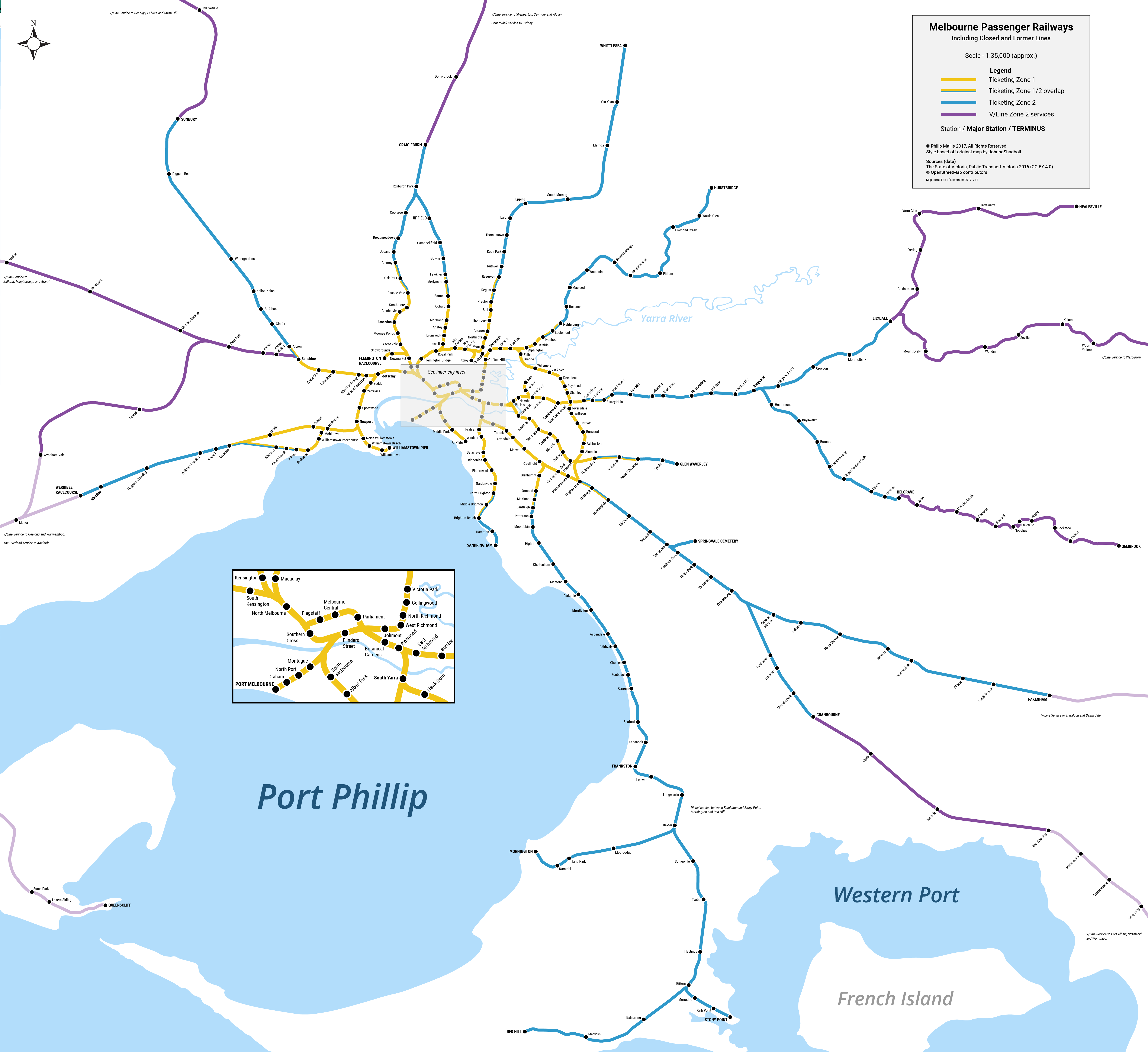
This time I am trying something a little bit different – a historical map of Melbourne’s railway lines.
The map shows what the city’s heavy rail network would look like today if no passenger railways had ever been closed down.
I should add that this map is not an exercise in wishful thinking or network proposals. It is purely something fun with which to play around and a visual representation of an interesting thought experiment.
The Map
Fans of geographic maps – rejoice! Unlike most of my previous projects, this one is geographically accurate rather than schematic.
I took the map that I recently made for Wikipedia showing the current railway lines in Melbourne and added in all closed and former railways that existed throughout the history of Melbourne. Obviously there is a little historical license that is further explained in the notes below.
When I began work on this, it seemed relatively straightforward. However, because of the close proximity of many railway stations and lines, trying to fit everything while keeping the map legible was challenging. The data required to trace the former railways was also quite patchy.
Looking at the completed map is pretty interesting. There are some obvious differences with entirely new lines in operation (e.g. the Outer Circle) but also some small changes that might not be entirely obvious at first.

Added Railway Lines
Outer Circle Line
Inner Circle Line (including Fitzroy North branch)
Port Melbourne Line
St Kilda Line
Kew Line
Mornington Line
Red Hill Line
Warburton Line
Healesville Line
South Gippsland Line
Queenscliff Line
Gembrook Line
Springvale Cemetery branch
Upfield to Somerton link
Extension of Werribee Line to Werribee Racecourse
Extension of South Morang Line to Whittlesea
Added Railway Stations
Werribee Racecourse
Galvin
Paisley
Mobiltown
Lyndhurst
General Motors
Williamstown Racecourse
Williamstown Pier
White City
Altona Beach
Hatherley
Manor
Botanical Gardens
Campbellfield
Operations
One consideration with making this map was how some former lines would operate. For example, were the Healesville and Warburton Lines still in existence, would they be run by Metro or V/Line?
This is more of a judgement call on my part than any sort of historical revisionism. In the case of Healesville/Warburton, I decided to make them V/Line-operated. I figure that there would be a small Sprinter or 2-3 carriage train shuttling back and forth between the two termini and Lilydale.
The Mornington and Red Hill Lines would be operated in the same manner as the Stony Point Line; that is with a train hired by Metro from V/Line.
Whittlesea didn’t seem to make much sense to operate separately given its isolation from the network and relatively proximity to Melbourne. Besides, being in the countryside hasn’t stopped the Hurstbridge Line from being operated with suburban trains.
As I said above, these were pure judgement calls on my part. Happy to hear alternative proposals and suggestions. This is a fictional scenario after all.
Other Important Notes
- I have only included passenger railways.
- Railway stations are named for what they were called at the time of their closure.
- There are two or three parts of the map that were impossible to make without screwing with some of the design rules, particularly with station labels. See the area around Hawthorn and Rushall for examples.
- I am aware that there was another East Camberwell Station just south of the present site on the Outer Circle Line. This is not included for practical space reasons, as well as the fact that it had the same name as the present station.
- Some of the ticketing zones have changed slightly from their present-day boundaries. I have made these changes based on the fact that with some of these railway lines in existence, the current zones would make no sense. For example, at the southern end of the Outer Circle Line, the present-day Alamein Line located entirely in Zone 1, would intersect with the Zone 1+2 overlap on the Glen Waverley Line. As a consequence, I have pushed the overlap out two stations on the Glen Waverley Line to begin at Holmesglen rather than Darling.
- Small branches in operation for very short periods of time, such as the St Kilda – Windsor branch, have not been included.
- Yes, the railway station was spelled ‘Queenscliff’ without an ‘e’.
Data
The data showing all current and former railways and railway stations was surprisingly difficult to find. There were several good datasets but none were totally comprehensive. In the end, I used a combination of:
- DEDTJR datasets from data.vic.gov.au
- OpenStreetMap data from Overpass.eu
- Wikipedia articles on closed lines and stations
Future Development
Not being someone very well versed in historic railways, I have probably made a couple of errors. If you find anything that is missing or needs improvement, please do not hesitate to let me know.
UPDATE 2017-11-04: thanks once again to the feedback from Reddit and rail Facebook groups, I have made a number of additions of railways and stations that I missed in v1.0:
- Added Gembrook Line (Puffing Billy)
- Added Springvale Cemetery branch
- Added Williamstown Racecourse Station
- Added Williamstown Pier Station
- Added White City Station
- Added V/Line track from Werribee
- Added Upfield to Somerton track
- Added Altona Beach Station
- Added Hatherley Station
- Fixed spelling of ‘Traralgon’
- Added Manor Station
- Added Botanical Gardens Station
- Added Campbellfield Station
I hope to also work on three further projects out of this map:
- A Victoria-wide geographic map showing all current and former railways;
- A schematic version of the Melbourne map; and
- A schematic version of the Victoria map.
Judging from my initial attempt on the Victoria-wide maps a few days ago that crashed Illustrator, this could take a while.
